GNSS
(Global Navigation Satellite System)
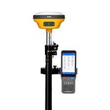
GNSS (Global Navigation Satellite System) surveying is a technique that uses satellite signals to determine the location of a point on Earth. It’s also known as GPS surveying.
How it works:
- A GNSS receiver, often a handheld device, collects signals from satellites.
- The receiver uses data from multiple satellites to calculate the position of the point.
Benefits:
- Accuracy: GNSS is more accurate than other methods.
- Speed: GNSS is fast, reducing the time it takes to get results.
- Safety: GNSS can increase safety.
- Ease of use: GNSS is easier to use than other methods.
Types of GNSS surveys:
- Static surveys: A type of GNSS survey technique .
- Kinematic surveys: A type of GNSS survey technique.
- Real-time kinematic (RTK) GNSS: A type of GNSS that uses real-time corrections from reference stations to achieve a higher level of accuracy.